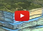
These remote automated levels are a cooperative effort between the District, Texas Water Development Board and Local Property Owners. The data for these sites is stored on the Water Data for Texas website found below. Most of these sites have been equipped and are maintained by the District. The levels are typically captured at 1-hour intervals and presented on a 24-hour delay. This means that levels for today will be available tomorrow. Satellite telemetry is more cost effective in the long term, but data collection is much slower. Accessing these links will take you away from the District website. The list of remote monitoring site below are the monitoring wells that are within the District boundary. A full list of remote automated site can be found on Water Data for Texas.
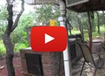
These remote automated levels are a cooperative effort between the District and Local Property Owners. The data for these sites are stored on the Wildeye’s website found at the links below. All of these sites have been equipped and are maintained by the District. The levels are typically captured at 15-minute intervals and presented on a 1-hour delay. These sites have cellular telemetry, so data transmission can be more frequent than satellite transmission. Accessing these links will take you away from the District website. The list of remote monitoring site below are the monitoring wells that are within the District boundary.